


Florida’s Coasts – Florida Beaches – National Seashores
Florida’s coastline is a masterpiece of natural engineering, a constantly shifting boundary where land, sea, and sky meet in a delicate balance of geology, biology, and time. Stretching more than 1,300 miles, it’s one of the most diverse coastal systems in the world. From the sugar-white sands of the Panhandle to the mangrove labyrinths of the Keys, every stretch of shore tells a different story written by waves, tides, and wind over millions of years. These beaches are not static landscapes; they are living systems, sculpted daily by natural forces and, increasingly, by human hands.
What makes Florida’s coast truly remarkable is its variety. The northern Gulf beaches shimmer with ancient quartz grains carried down from the Appalachian Mountains. Along the Atlantic, coarser sands mixed with shell fragments create steeper, more energetic shores. In the south, coral reefs, limestone flats, and tangled mangrove forests take over, forming habitats that buffer the land from storms and nurture countless species. Together, they make up a coastline that is as biologically rich as it is geologically young.
But beneath its beauty lies a constant tension. Florida’s shores are always on the move, eroding, rebuilding, reshaping. Wind lifts sand to form dunes, waves transport sediment alongshore, and storms can redraw entire islands overnight. The very processes that create the state’s postcard-perfect beaches are also those that threaten them. And as sea levels rise and development presses closer to the water’s edge, understanding how these systems function has never been more important.
To study Florida’s coastline is to study change itself. Every grain of sand, every tide line, and every mangrove root tells a story of adaptation, of how nature responds to shifting forces and, increasingly, how we must learn to do the same.
How Florida’s Coast Was Formed
To understand Florida’s coastline, you have to travel back in time millions of years, to when the state didn’t yet exist above the sea. What we now call Florida began as a carbonate platform, a vast shelf of limestone formed from the accumulation of marine shells, corals, and microscopic organisms that lived in warm, shallow seas. Over time, layers of these calcareous sediments compacted and hardened into the bedrock that lies beneath the peninsula today.
During the Pleistocene epoch, roughly 2.5 million to 12,000 years ago, the planet cycled through repeated ice ages. When glaciers advanced, global sea levels dropped, exposing parts of the continental shelf; when they melted, the seas rose again, flooding the land. These fluctuations sculpted Florida’s outline again and again creating ancient shorelines that now sit miles inland and leaving behind the terraces and fossil dunes visible in places like the Lake Wales Ridge and the Ocala region.
The sand that defines so much of Florida’s coast has its own remarkable journey. Much of it originated in the Appalachian Mountains, hundreds of miles to the north. Over millions of years, rivers carried quartz grains southward, depositing them into the Gulf of Mexico and along the Atlantic shelf. Ocean currents and waves then reworked these sediments into the beaches and barrier islands we know today. That’s why the sands of Florida’s Panhandle and Atlantic coasts are so pure and bright, they’re the worn remnants of ancient mountains, shaped by water and time.
In the south, the story changes. The Florida Keys and parts of the lower peninsula rest atop coral reef structures and marine limestone, built not by erosion but by life itself. Coral polyps, algae, and other organisms created massive reef systems during warmer interglacial periods, forming the foundation of islands that now barely rise above sea level. Even today, this living reef tract continues to influence how sediment moves, how waves break, and how new land slowly forms.
Together, these processes, the uplift and submersion of the platform, the migration of sand, the building of coral, and the carving power of waves, produced a coastline that is both fragile and resilient. It’s a landscape still being written, one tide and one storm at a time.
Barrier Islands: Florida’s Natural Shields
Stretching along much of Florida’s Atlantic and Gulf coasts, barrier islands are among the most dynamic and vital features of the state’s coastal system. These long, narrow ribbons of sand lie parallel to the mainland, separated by lagoons, bays, or estuaries. Though they may look permanent on a map, barrier islands are in constant motion, forming, shifting, and sometimes disappearing altogether under the forces of wind, waves, and storms.
Scientifically speaking, barrier islands are products of sediment transport and wave action. As waves approach the coast at an angle, they push sand along the shore in a process known as longshore drift. Over time, this movement piles up sediment into elongated ridges offshore. When sea levels stabilize, these ridges rise above the waterline, forming new islands. Behind them, quieter waters allow fine sediments to settle, creating the lagoons and marshes that separate islands from the mainland.
Florida’s barrier islands play a crucial ecological and geological role. They act as natural shields, absorbing the brunt of storm surge and wave energy before it reaches the mainland. Without them, many of Florida’s coastal communities, and its fragile estuaries, would face far greater damage from hurricanes and erosion. These islands also provide critical habitat for nesting sea turtles, shorebirds, and dune plants that hold the sand in place.
Yet their mobility is also their vulnerability. Barrier islands migrate landward over time, a natural response to rising sea levels and wave overwash. During major storms, waves can cut new inlets or move entire sections of an island, redistributing sand across the landscape. This process, known as island rollover, helps maintain the island’s shape and elevation in the long term. But it can also erase roads, structures, and developments built too close to the shifting edge.
Human efforts to “fix” these islands, through seawalls, jetties, and beach renourishment, often disrupt the very processes that keep them alive. A jetty may protect one beach but starve another of sediment. Renourishment can widen a shoreline temporarily, but the imported sand is soon carried away by the same forces that shaped the coast in the first place.
Florida’s barrier islands, like Anastasia, Sanibel, Santa Rosa, and Amelia Island, each tell their own story of balance and transformation. To scientists, they are not static landscapes but living laboratories, showing how nature defends, rebuilds, and renews itself against the relentless rhythm of the sea.
Beaches and Sand Dynamics: The Ever-Changing Shoreline
Florida’s beaches are constantly in motion, sculpted by the same forces that shaped them in the first place: waves, wind, and tides. The sand you walk on today may be gone tomorrow, transported by the sea or buried beneath the shifting dunes. Understanding how sand moves and how beaches evolve is key to preserving these dynamic environments and protecting the communities that depend on them.
One of the most important forces shaping Florida’s beaches is littoral drift, the process by which sand is carried along the shore by waves approaching at an angle. As waves hit the coast, they push water and sediment in a diagonal direction. This causes sand to move down the beach, creating a flow that stretches along the coastline like a conveyor belt. Over time, littoral drift can carry sand hundreds of miles, reshaping the shape of the coastline.
However, this movement is not uniform. The energy of waves varies from one coast to another, which is why Florida’s beaches are so different from region to region. On the Panhandle, where wave action is gentler, the beach has wide expanses of fine, white quartz sand, which is carried across long distances by currents. In contrast, the Atlantic Coast, exposed to stronger wave action, has narrower, steeper beaches and coarser sand mixed with shell fragments. This variation in sand composition is the result of the differing energy levels of waves and the types of materials available for erosion and deposition.
In addition to wave action, wind plays a crucial role in the movement of sand on Florida’s beaches. During strong winds, sand grains can be picked up from the surface and carried inland, creating sand dunes. These dunes, along with the vegetation that stabilizes them, form a natural barrier against coastal erosion, preventing sand from being swept away during storms. The combination of wind and wave action also explains why the beach changes so rapidly: while waves shape the beach on a daily basis, wind can alter its structure in a matter of hours.
Yet, while the beach itself is a constantly shifting landscape, human activity has introduced new dynamics. Coastal development, such as seawalls and piers, often interferes with the natural flow of sand, causing erosion on down-drift beaches. Beach renourishment, which involves importing sand from offshore or inland sources to widen eroded beaches, is a common practice in Florida but it is not without complications. Though renourishment temporarily stabilizes the coastline, it does not address the underlying forces of erosion. Imported sand often disappears quickly, carried away by the same currents that moved it into place.
At the heart of Florida’s sand dynamics is a sediment budget, the balance between sand being added to the system through deposition and sand being lost to the ocean through erosion. When the sand budget is positive, beaches grow and widen; when it’s negative, beaches shrink, and coastal erosion intensifies. The balance is constantly shifting due to both natural forces and human intervention.
The science of sand movement is crucial for understanding coastal resilience. Beaches serve as a first line of defense against storms and rising sea levels. When erosion accelerates, it can not only affect the physical landscape but also threaten the ecosystems that rely on beaches, like sea turtles that nest in the soft sands, or coastal plants that anchor dunes. By studying the forces that shape the sand, scientists can better predict changes, manage coastal erosion, and develop sustainable strategies to protect Florida’s beaches for future generations.
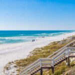
Dunes: Florida’s Natural Fortresses
Rising just beyond the high-tide line, Florida’s sand dunes may look like simple mounds of sand, but they are among the most critical and complex structures along the coast. These rolling ridges, often draped with sea oats and wildflowers, form a natural defense system that protects inland areas from storm surge, saltwater intrusion, and coastal erosion. Without dunes, the power of the ocean would reach far deeper into Florida’s low-lying landscape.
Scientifically, dunes are formed by a combination of wind, vegetation, and sand supply. When wind blows across a beach, it lifts fine sand grains from the surface and carries them inland. As the wind loses strength, these grains settle and accumulate, often around a piece of driftwood, a shell, or a plant. Over time, the mound grows, and once vegetation takes root, the dune stabilizes. The plants act like anchors, trapping more sand and preventing it from being blown or washed away.
Among the most important of these plants are sea oats (Uniola paniculata), tall, flexible grasses whose deep root systems can extend several feet below the surface. Sea oats are especially adapted to Florida’s coastal environment: they thrive in salty air, shifting sands, and direct sunlight, and they play a central role in dune formation and stability. Other species, like beach morning glory and bitter panicum, work together to hold the dune in place, creating a living matrix that allows the dune to grow and recover after storms.
Dunes are not static landforms; they are part of a dynamic coastal system. During calm weather, they accumulate sand carried by the wind. During storms, waves often erode the seaward face of the dune, pulling sand into the surf zone, where it helps absorb wave energy and reduce coastal flooding. Once the storm passes, the wind gradually carries that sand back onto shore, rebuilding the dune over time. This natural cycle of erosion and recovery allows dunes to act as both shield and sponge, absorbing the impact of storms while maintaining the long-term stability of the beach.
However, dunes are highly sensitive to disturbance. Foot traffic, off-road vehicles, and coastal development can all damage the vegetation that holds the sand in place. When plants die or are removed, the dune becomes unstable and begins to collapse, exposing the coastline to erosion. Even small disruptions, like paths cut through dunes without proper management, can create channels for storm surge, amplifying the damage during hurricanes. That’s why dune restoration projects are now a central part of Florida’s coastal management strategy.
These restoration efforts often involve planting native dune vegetation, installing sand fences to trap windblown sand, and limiting human access with boardwalks and designated walkways. By encouraging natural dune growth, these programs not only protect infrastructure but also help maintain critical habitats for species like beach mice, nesting sea turtles, and shorebirds.
In many ways, dunes represent the perfect balance of resilience and fragility. They are strong enough to withstand the ocean’s force yet delicate enough to collapse under careless pressure. As Florida’s storms intensify and sea levels rise, the health of these dunes will be a key factor in how well the state’s coastline adapts to the future. They remind us that nature’s best defenses are often the ones built by time, patience, and the quiet cooperation of wind and plants.